Photograph
Is an image of an object which is recorded by a camera and then printed on paper
Or
Is a picture taken by means of chemical lights prepared on a special paper
Types of photographs
i) Horizontal photographs/Group photographs
ii) Oblique photographs
iii) Vertical photographs
1. HORIZONTAL PHOTOGRAPHS/GROUP PHOTOGRAPHS
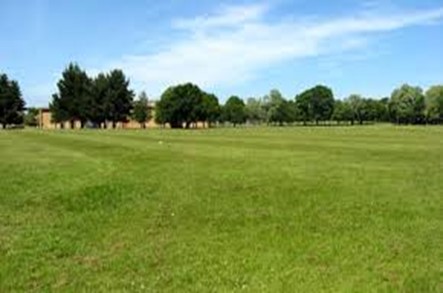
These are photographs that are taken from the ground when the camera is at the same level as the object being photographed.
Objects are large and clearly shown in these photographs when they are close than those far from the camera
The fore ground and the horizon is seen but the back /dead ground is not seen
There is no fixed scale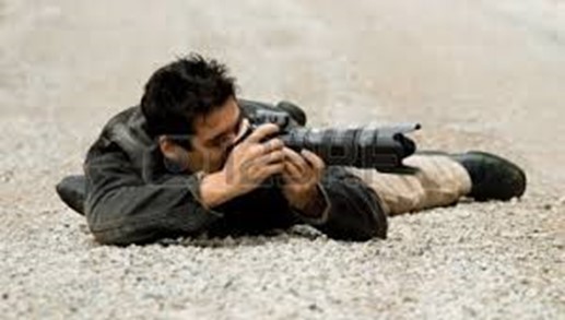
2. OBLIQUE PHOTOGRAPHS
Are the photographs taken hen a camera is slanting at an angle less than 90°. They are taken when the photographer is standing on an elevated ground and hold the camera on an angle towards the lower ground .They normally cover the horizon.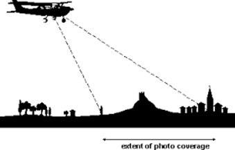
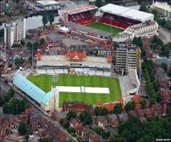
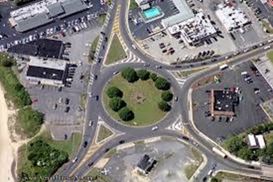
3) VERTICAL PHOTOGRAPHS
These are photographs taken from the air with the camera directly above the object pointing vertically to the ground.
Only the top view is seen
Instruments used to capture pictures are called air crafts or the satellites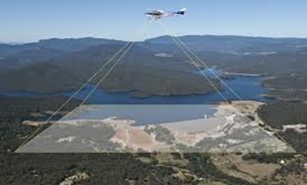
These are various differences between 3 types of photographs as follows.
|
Ground photographs |
Vertical photographs |
Oblique photographs |
|
Are taken when the camera is at the same level with the object |
Are taken from the air vertically above objects being photographed |
Are taken from the ground or from air with the camera tilted below 900 |
|
They show side of the object facing the camera. |
It shows only the top side of the object |
Shows the top and sides of the object |
|
Size of object near the camera are large than those far away |
Objects in the center are larger than those away from the center |
Objects closer the camera are larger than those far away |
|
Show relatively small area |
Show relatively large area |
Show relatively largest area possible |
edu.uptymez.com
PARTS OF PHOTOGRAPH
In order to study and refer the position in the photograph properly ,It s necessary to divide photograph into appropriate parts .The photograph is devided into three parts both horizontally and vertically .
Horizontally ,It is divided into foreground, middle ground and back ground .The foreground is the area nearest to the camera,middle ground is the area between foreground and the back ground ,where as background is the furthest area from the camera.
middle ground is the area between foreground and the background, where as background is the farthest area from the camera.
For case of description of location onto features on the photograph it is appropriate to use these division.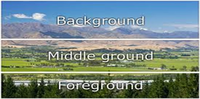
|
Left |
Centre |
Right |
|
left background |
central background |
right background |
|
left middle ground |
central middle ground |
Right middle background |
|
left foreground |
central foreground |
right foreground |
edu.uptymez.com
The table gives appropriate description of both horizontal and vertical interpretation of photograph
READING AND INTERPRETATION OF PHOTOGRAPH
Is the process of reading, measuring, translating and explaining the meaning of objects identified on that photograph.
It is done so as to obtain reliable information about the natural or cultural features on their environments. It involves the following;
Determining the title
Estimating time and the season
Estimating direction
Identifying and nglish-swahili/interpreting” target=”_blank”>interpreting physical features
Identifying and nglish-swahili/interpreting” target=”_blank”>interpreting human activities
Estimating the size of phenomena
Suggesting possible location of the scenery in the place
DETERMINING THE TITLE
Can be obtained by carefully studying the photograph, information determines the choice of the title. Photos show landscapes, activities on land, what is on the surface and the sky. The information contained in the foreground, middle ground and dead ground can help in determining a suitable title
ESTIMATING TIME AND SEASON
It is possible to estimate the time of day when the photo was taken if we know where the photograph was taken
1) If the photo was taken during the morning its evidence is through the shadow
During the morning
The shadow of the object lies in the western side because the sun rises from the east
2) During the evening
The shadow lies in the eastern side because the sun sets on the west
3) During the after noon
The shadow lies around the object because the sun is over head of the object
SEASONS
- A bright sky with dry vegetation may indicate a dry period or season.
- Thick vegetation young crops or flowering plants in the field and a sky full of rain clouds indicate a rainy season
- Clear sunny conditions with health vegetation and flowering plants or plants with fruits indicate summer season
- Plants with young leaves others bloom and field full of grass indicates spring season
- Hazy sky with leafless trees and some snow on the ground indicates winter season
- Also when people appear to be wearing heavy clothes with faces almost completely covered, hand gloves and heavy boots it indicates cold weather, likely winter in temperate regions
- People wear light clothes and some may even have broad-rimmed hats indicates hot weather
- When houses appear to have slanting roofs it indicates the region experiencing a lot of precipitation which facilitates the easy flow of water from the roof of the house
- If people appear to be planting then it is planting season the rains either are about to come or have just started
- If the people appear to be weeding it is growing season for the crops and there is reduced rainfall
- If people appear to be harvesting a crop it is harvesting season and probably dry season because harvesting normally takes place during dry weather.
edu.uptymez.com
ESTIMATING DIRECTION
- It is possible to estimate direction on the photo using shadows if time and place are known
- If a photograph shows trees whose shadow is on the right and is taken in the morning the photographers direction is south
- If the shadow is pointing towards you on the photo and the photo was taken in the afternoon (sun was in the west) then the camera was facing westwards.
edu.uptymez.com
IDENTIFICATION AND INTERPRETATION OF PHYSICAL FEATURES
Many varieties of physical features can be identified on photographs. These includes features of relief, drainage and vegetation
A) RELIEF
It is necessary to first identify feature of relief on the given photograph. These features appear the way they do in real nature .When describing relief on photograph one should start giving a general idea about the area shown in the photograph.
On the ground photograph, it is possible to identify flat land scapes ,hilly areas and mountainous relief. Other details can be fitted within this general outlook.
B) DRAINAGE
Drainage features such as rivers, lakes and other alike water bodies can be easily identified on all types of photographs. On ground/Horizontal and some obliques rivers may not be easy to study because of obstruction and intervening obstacles ,
Different aspect of rivers can be studied including the shape of either valleys and develop of different features. For example ;presence of rapid waterfalls is an indication of river flowing over steep land , River meanders indicates the mature stage of the it or even old stage .Drainage pattern. May indicate the highland areas and normally can be taken by aerial photograph while presence of big meanders, lake or ocean indicate lowland areas with high rate of deposition as the effect of erosion done at highland areas.
C) VEGETATION
Photograph shows all types of vegetation present in the photographed area. It is however difficult to distinguish certain types of vegetation foristance natural from derived vegetation. Planted vegetation may be easier to identify because of their unique character .Trees in clear straight row and the same height in photograph indicate the planted forest ,where as random arrangement and height indicate the natural vegetation .
Photograph interpretation with thick forest and greenish indicate the area with arable rainfall and rich in fertile ,photographs with less vegetation indicate the area with less or no rainfall which referred as semi- arid and arid areas in this areas photos may also show cactus plants acacia trees, jacaranda plants etc
CLIMATE
Climate is not shown in a photograph but can be used to give conclusion on the type of an areas. The characteristics of the sky can give a clue about the weather and season when the photo was taken ,
(a) Presence of thick cumulus or cumulonimbus clouds indicate a rainy season while a clear sky may imply a dry season
(b)The type of clothing people in the photograph are wearing gives a clue about the weather and possible climate i.e. light clothe indicates the hot climate condition and heavy clothes indicates the cold condition
(c) The type of vegetation shown, provides a clue about the season or climate of a place
For example ; presence of numerous cacti may indicate the semi arid or arid climate ,crops such as sisal grown in hot areas that may receive low rainfall while sugar cane thrives in warm to hot climate with high rainfall.
IDENTIFICATION AND INTERPRETATION OF HUMAN ACTIVITIES
FARMING/ AGRICULTURE
Crop cultivation and live stock keeping
Vertical aerial photographs may require close scrutiny to be able to identify. It is fairly easy to distinguish these two types of ground photographs
|
Type of farming |
Evidence to look for. |
|
1. Subsistence crop farming |
edu.uptymez.com
edu.uptymez.com
|
|
2. Subsistence live stock farming. |
edu.uptymez.com
|
|
3. Commercial live stock farming |
RANCHING
edu.uptymez.com
DRY FARMING
edu.uptymez.com
|
|
4. Commercial crop farming |
edu.uptymez.com
|
|
5. Plantation farming |
edu.uptymez.com |
edu.uptymez.com
SETTLEMENTS
Settlement comprises a group of buildings in area where people live and carry out social and economic activities
Settlements may be of two main groups:
i) Rural
ii) Urban
RURAL SETTLEMENTS
Can be indicated by;
- Simple semi permanent and permanent buildings such as grass roofed houses or iron roofed houses with mud or brick walls
- Farming, grazing or fishing
- Unplanned presence of villages
edu.uptymez.com
URBAN SETTLEMENTS
- Permanent buildings
- Regular street patterns
- Many large buildings and ware houses for industrial area
- High number of people if shown
- Many motor vehicles
- Port facilities [ docks, cranes, ware houses, containers]
edu.uptymez.com
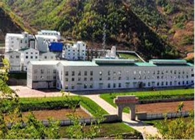
INDUSTRIAL AND MINING ACTIVITIES
Evidences
- Factory buildings with tall chimney for issuing smoke
- Large ware houses next to the building
- Large lorries carrying loads of rocks indicates open cast mining
- A vast area with derrick/oil rigs indicate oil fields
edu.uptymez.com
Also lumbering activities
- people cutting trees
- people loading trees /lumber on lorries
- logs floating down on rivers
- logs pilled near a sawmill
- large forest clearings
- Many road ways ending on the forest.
edu.uptymez.com
TRANSPORT AND COMMUNICATION
The following are some of the dues on transport
- motor vehicles and roads
- a railway line
- Presence of boats and ships and large water vessels
- Animal carrying loads on their backs
edu.uptymez.com
Facilities for communication are due to the presence of
- Telephone lines
- Telephone booths
- Satellite dishes
- Televisions
edu.uptymez.com

