DRAINAGE PATTERNS
All the rivers are joined by smaller rivers or stream which are called tributaries .The area drained by rivers and the its tributaries is known as a rivers system or catchment area and its boundary is usually formed by the crest line of the surrounding highland called the watershed .
The watershed separates one basin from the next basin. The main river and all the its tributaries together form a river system.
A river system develop a pattern that is related to the general structure of its basin . There are these basin river system patterns.
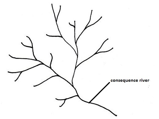
(i)Dendritic: This pattern has a shape like the trunk or branches of a tree with the tributaries joining the main stream is called a consequent stream or(river) because it develops as a consequence of the slope This drainage pattern develops on rocks of uniform structure and hardness
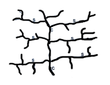
(ii)Trellis : A trellis pattern develops in a region which is made up of alternate belts of hard and soft rocks , which all dip in the same direction and which lie at right angles to the generally slope down which the consequent stream flows . The tributaries extend their valleys by head ward erosion into the weak rocks which are turned into wide valleys, whilst the hard rock stand up has escarpments . The tributaries which cut out the valleys and which do not flow down the main slope , are called subsequent rivers. This pattern develops in scarp land regions and regions of forded rocks.
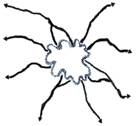
(iii) Radial , This pattern develops on a dome or cone shape upland , such as volcano. The rivers flow outwards forming a pattern like the spokes of a wheel.
HYDROLOGICAL CYCLE
Hydrological cycle in the endless or continuous interchange of water between the atmosphere, the earth (land) and water bodies. It is the circulation of water from ocean into the atmosphere through combined effects of evaporation , transpiration, condensation and precipitation
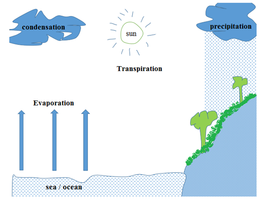
Evaporation: The process in which liquid water turn into water vapour and rises up.
Transpiration: The loss of water vapour from plants in the form of vapour to the atmosphere.
Condensation: The process in which water vapour turns into the liquid form following a drop in atmospheric temperature. The temperature at which condensation takes place is called dew point. The dew point is the temperature at which the water vapour in air at constant barometric pressure.
Precipitation: This refers to any product of condensation of atmospheric water vapour that fall under gravity. The main forms of precipitation include drizzle, rain, sleet, snow, hail and graupel. Precipitation occurs when a portion of the atmosphere becomes saturated with water vapour, so that the water condenses and “precipitates”.
UNDERGROUND WATER
When rain falls, some water forms streams (surface run off) while some penetrates into the ground (percolation process). The water that seeps into the ground forms underground water. Water enters the rock in two ways:
- Via the spaces, called pore spaces, separating the individual grains of rock; and
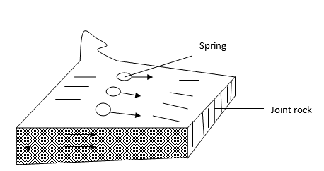
- Via the joints or faults in a rock.
edu.uptymez.com
Percolation:
This refers to the process in which water on the ground surface seeps down into the ground.
Porous rock:
This is a rock which has pore spaces into which water can infiltrate, e.g. sand, gravel, sandstone, etc.
Pervious rock:
This is a rock which has joints or faults into which water can infiltrate, e.g. limestone, chalk, and granite.
Permeable rock:
This is a rock which allows water to penetrate through it, e.g. they have open texture and have poor cementation. They include limestone, sand, gravel, sandstone, etc.
This is a rock which does not allow water to pass and penetrate through it, e.g. clay.
Some rocks are both porous and permeable, e.g. sandstone, and some rocks are porous but impermeable e.g. clay. When the pore spaces of a rock are filled with water, the rock is said to be saturated.
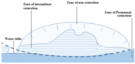
Water table
The water table can be defined as the depth at which the ground becomes saturated with water. It can also be defined as the level below which the ground is completely saturated with water. The saturated zone beneath the water table is called an aquifer, and aquifers are huge storehouses of water.
Water zone
The water entering surface rocks moves downward until it reaches a layer of impermeable rock when further downward movement ceases. There are three water zones as explained below:
Zone of non-saturation: This is the zone which is filled with water only during a precipitation. In this zone pores have open textures that allow water to pass through them. The zone is found immediately below the surface.
Zone of intermittent saturation: this is the zone which is filled with water and remains with water for a long time during heavy rain. the pores of this zone are filled with water during a heavy rainfall but after the rainfall ends it becomes dry.
Zone of permanent saturation: This is the zone which is always saturated with water. It does not become dry rather than extending far deep in the ground. It is suitable for sinking permanent wells. The last two zones, that is, zone of intermittent and non-saturation zone are sometimes called phreatic since they saturate only once.
Wells and artesian wells
A well: A well is the hole sunk below the water table. Always wells which are sunk below the water table (i.e up to zone of permanent saturation) have water throughout the year.
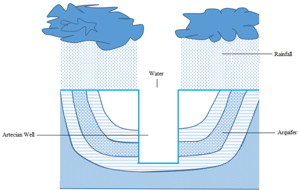
Artesian well: This is a well which sinks in the aquifer of an artesian basin. When a well is sunk into an artesian basin, the hydrostatic pressure in the ground forces the water to come out. The artesian well in which water does not reach the surface is called semi-artesian well.
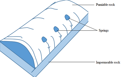
Spring: A spring is a natural of outflow of underground water to the surface. Some springs are permanent if the water table is permanent and they can be temporary if the water table is temporary also.
Formation of a spring
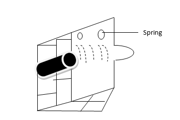
I. It may be formed when a impermeable rock underlie a permeable rock in a hill. In this feature the permeable rock lies on top of an impermeable rock causing water outflow.
II. A spring may also be formed when well-jointed rocks form a hill.
III. When a dyke acts as a dam. If it cuts across a layer of permeable rock then the water on the up-slope side of the dyke is impounded. This causes the water table to rise and a spring develops where the water table meets the surface.
IV. A spring may also be formed in a limestone region when chalk or limestone escarpments overlie impermeable rocks
V. When gently-sloping layers of a permeable rock alternate with a layer of impermeable rock.
Importance of underground water
i. It is very important in the weathering of rocks; hence it assists in soil formation.
ii. The springs and wells provide water for domestic and industrial uses such as drinking e.g. the Mzima spring in Kenya.
iii.It is very important for growth and survival of plants and some living organisms found in the surface soil
iv. In developed countries, hot springs have been harnessed for heating up houses during severe winters (e.g. in Iceland and Greenland) as well as for hydro-electric power generation.
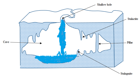
v. It is very important in the growth of Karst (hanging stone) features which attract tourist, hence source of foreign exchange. For instance, stalactites, stalagmites, pillars and caves.
KARST LANDSCAPE
Karst landscape is a landscape formed from the dissolution of soluble rocks such as limestone, dolomite and gypsum. It is characterized by underground drainage systems with sinkholes, dolines and caves.
Limestone consists chiefly of calcium carbonate (CaCO3) which is insoluble in pure water but it is soluble in rain water containing a weak carbonic acid (H2 CO3). Limestone is a well –jointed rock. The rain water and river remove limestone in solution. The carbonic acid in rain water dissolves limestone into calcium hydrogencarbonate, which is soluble an can easily be washed away in solution.
H2CO3+CaCO3Ca (HCO3)2
In this way, limestone regions may be removed or washed out to produce the following surface and underground features:
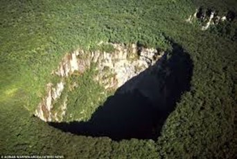
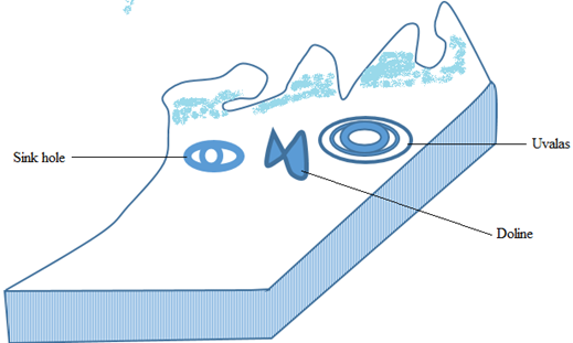
Sinkhole – a vertical depression or hole in the ground, sometimes called shallow hole, formed by river that sinks down when passing through a limestone region. It can be a source of an underground river.
Doline – a large depression formed when several shallow holes join together.
Uvala – a large depression formed when several dolines join together.
Polje – a very large depression that develops in association with faulting. It is a feature which is formed when several uvalas collapse, the collapsing associated with faulting. It usually covers several square kilometers (usually 5 to 400 km2).
Stalactite – an outcrop rock in the cave growing from the roof of the carven towards the floor.
Stalagmite – an outcrop rock in the cave growing from the bed of the carven towards the roof.
Pillar – a feature formed in a limestone cave when a stalactite and a stalagmite join together. It is sometimes called natural pillar.
Cave or cavern: A cave or cavern is an underground hole formed due to solution of limestone rock. First, the tunnels are formed, followed by enlargement of a hole. Caves form naturally by the weathering of rock and often extend deep underground.
An example of a limestone landscape is the Matupi cave in Hoyo mountain in DRC.
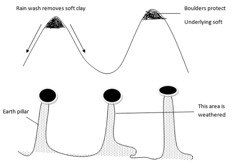
Features formed by rain action
Rain action produces several types of features of which the most common are gullies and earth pillars
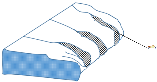
1. Gully
This is a deep formed by the action of running water on gently sloping land that has little or no vegetation. Gullies are sometimes referred to as badlands. They develop largely in semi –arid areas.
2. Earth pillar
This is the up-standing ridge capedwith boulders. It is formed when rain falls on the mountain slopes consisting of boulders and clay is removed rapidly except where boulders protect it.
WIND ACTION AND THE FEATURES IT PRODUCES
Wind refers to the air in motion from high pressure to low pressure belt. Wind action is very powerful in arid and semi-arid regions. Examples of deserts include the Sahara, in Africa, Namib, Kalahari and Gabi deserts.
Types of desert surfaces
Sandy Desert (Erg): This is a undulating plain of and whose surface is blown into sand dunes and nipples. The Sand Sea of Egypt and Libya is a good example of an erg.
Stony Desert (Reg): This consists of extensive areas with boulders and stones produced by daily temperature changes. Most of story deserts are formed in Algeria, Libya and Egypt
Rocky Desert (Hamada): This consists of extensive areas of bare rock from which all fine materials have been removing by deflation. Abrasion by the fine materials polishes and smooths the rock surface. One of the largest Hamada is Hamada el Hamra, in the Sahara of Libya.
Badlands: This is a land broken by extensive gullies, separated by steep-sided ridged. This type of desert is quite different from the three deserts explained above, in that it develops in sem-arid regions which experience sudden violent rainstorms.
WATER ACTION IN THE DESERT
Running water in the desert result the formation of fluvial features.
Fluvial features
Are the features which resulted due to the influence of water action.
The fluvial features can either fluvial depositional features or fluvial erosional features.
DESERT FLUVIAL EROSIONAL FEATURES
Desert fluvial erosional features are also known As Desert water erosional features.
These are the erosional features which caused water action in the desert.
Desert fluivial erosional features include the following.
i. Rills: –
Are the small shallow grooves formed due to rill erosion effected by surface run off
ii. Gullies: –
Are deep steep sided trough produced when erosion in the rills become more concentrated into the ground
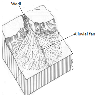
iii. Wadis: –
Are the steep sided deep and often flat floored valleys formed due to severe erosion by water in the desert.
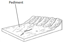
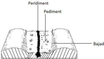
iv. Pediment.
Is a gently sloping platform formed when edges of the desert and semi desert high lands get pushed back by erosion and weathering.
The process whereby pediments is called pedimentation.
v. Pedi plans / Pad planes
– Are the multiconcave features resulted by several adjacent of large scale pediments.
– They are formed as a result of wide spread surface water erosion on the surface in desert areas.
WATER DEPOSITIONAL FEATURES IN THE DESERT
Are the depositional features formed when the materials carried by running water accumulated and deposited in some parts of the desert surface.
The desert water depositional features include the following.
- Alluvial cones.
edu.uptymez.com
Are the features which look like alluvial fans in shape but consist of coarser materials
– They are formed when large coarser materials deposited at the foot of steep slope. Thus, they are formed in the same way to alluvial fans.
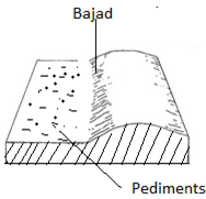
- Bajads or Bahadas.
edu.uptymez.com
Are the continous gentle sloping features with undulating surface formed when either alluvial fan or alluvial cones coalesce during deposition of more sediment at the foot a steep slope.
– They consist of angular scree, gravels and coarse sands around the margin of the basin.
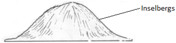
vi. Inselbergs: –
Are the residual hills or rock masses formed by water erosion in the desert
– They are always rounded and smooth
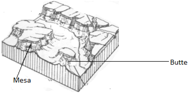
vii. Mesas and buttes
Mesas are extensive flat topped residual table lands which are generally capped with resistant rock stratum.
Buttes are the small but prominent residual flat topped hills usually capped with resistant rock stratum which remain a mesa and are similar to mesas except that they are small.
viii. Dry river valleys.
Are the river valleys which remain dry after the streams of water dry during dry season in the desert landscape or along the base of the mountain range in the semi desert area
ix. Peripediment.
Is a feature with a gentle slope formed when alluvial deposits overlie the edge of the pediment.
x. Plays and Salinas
Are the temporary salt lakes. Sometimes these playas dry up produce salt beds or salt flats called Salinas or Salas.
WIND ACTION IN THE DESERT.
Wind action is also known as Aeolian. It causes erosion transportation and deposition of materials in the desert.
WIND EROSION
Refers to the remove of particles on the desert surface.
Wind erosion consists of three main processes. These are
- Deflation
edu.uptymez.com
Is the process by which small the wind blows away loose rock waste and in doing so lowers desert surfaces producing deflation.
- Abrasion
edu.uptymez.com
Is the process by which small particles of rock are hurled by wind against the rock surfaces helping to produce features like rock pedestals, Zeugen and Yardangs.
During abrasion, the wind exerts the blessing action and uses its load as the tool for polishing and undercutting the surface.
- Attrition.
edu.uptymez.com
Is the process by which the rock particles rule or collide against each other as they carried along with wind. The particles get progressively reduced in size through this way until they become finer and finer.
WIND EROSIONAL FEATURES
The desert wind erosional features include the following
1. Rock pedestals
Are the tower like structures composed of alterate bands of soft and hard rock produced due to wind abrasion in the desert. As abrasion goes on attacking the weaker rock, the pedestal may break at the base and collapse.
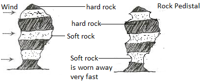
There are rock pedestals in Saudi Arabia, Tibest Mountains in central Sahara and in Niger.
ii. Zeugen
Are the ridge consisted of alternate layers of hard and soft rock overlying vertically downward.
– They are formed in areas where the rock layers lie horizontally and are characterized by joints.
– The weathering process first opens up the joints and then wind abrasion continues the work of weathering leading to the formation of furrows and Zeugen

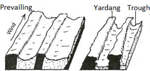
iii. Yardangs
Are the ridges consisted of hard and resistant rock bands standing either vertically or at an angle and can vary in height from 5m to 15m but having lengths of up to 1000m.
The yardangs are parallel to the direction of the prevailing wind. Example: – Yardangs can found near Salah (central Algeria and near Kom Ombo in Egypt.
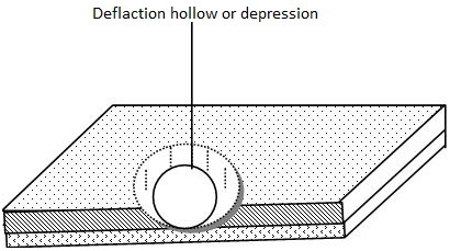
iv. Blowouts
– Blowouts are also known as Deflation hollows or pans.
These are the hollows or depressions produced by wind deflation.
– The small hollows are known as pans and are common in Kalahari Desert.
– Larger hollows like Qattara Depression in Egypt were formed by wind deflation.
– When these hollows are filled with water oases are formed.
v. Inselbergs
– Are the residual hills consisted of hard and resistant rock left standing on the surface after the rest part of the earth has been eroded
– When inselbergs are smooth and round in shape are called bornardts
– When the inselbergs are characterized by a lot of joints with rectangular rock blocks pilled together to produce a castellated form are called Kopjes
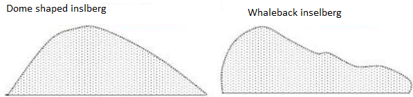
Note: – Inselbergs investigated that, many of them in the desert are formed due to the water action rather than wind action.
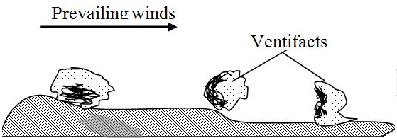
vi. Ventifacts
Are heavier rock blocks or pebbles left behind after the wind has sorted and carried away all material.
– They are sharpened and flattened as they lie by the action at the sandblast passing over them
WIND ACTION DEPOSITIONAL FEATURES
The material transported by wind from different features after deposition. The features formed include the following
- Sand Dunes
edu.uptymez.com
Are the hills of sand which have been deposited by winds in the desert
The formation of sand dunes is influenced by the extent of vegetation cover, the size of particles amount of the material and velocity of the wind.
There are two main types of sand dunes.
These are
i. Barchans
ii. Seifs
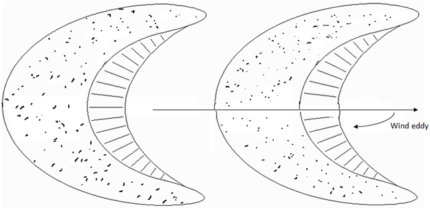
BARCHANS / BARKHANS
Are the crescents – shaped sand dunes which occur individually or in groups.
– Development of barchans is usually influenced by the obstruction which may be a tree or large stone.
– The windward side of the barchans is steep and slightly concave.
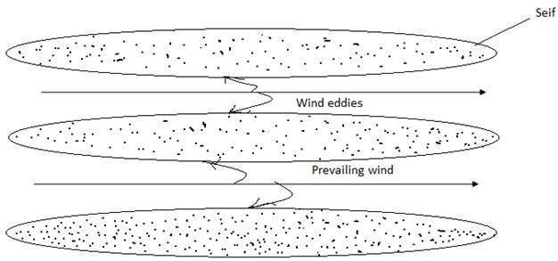
SEIF DUNES
– Seif dunes are also known as longitudinal dunes.
– They are long narrow ridge of sand which lies parallel to the direction of the wind.
– They usually occur on the small scale in sandy areas such as along the coasts and in the extensive sides of the river valley but such sand dunes are in small size because of the limited supply of sand.
LOESS
Is the accumulation of the fine particles of sand that have been carried beyond the limit of deserts.
– They are mostly found in loess plateaus of the China.
– The loess leads to the formation of fertile soil
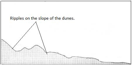
RIPPLES
– Are the smallest wavy structures, sometimes less that a centimeter high.
– They are commonly between the dunes
GLACIATION
Glaciation refers to the process whereby a certain area on the earth’s surface is affected by glaciers (moving ice). Glaciations also refer to the process that takes place due to the influence of moving ice.
Glacial erosion
Glacial erosion, which predominates in the highlands, consists of the following mechanism or processes.
Sapping: This refers to the breaking up of rocks by alternate freezing and thawing of water at the bottom of cracks between a mass of ice and the side and floor a valley, or the side of a mountain.
Plucking: This is the tearing away of the blocks of rock which have been frozen into the sides or bottom of a glacier.
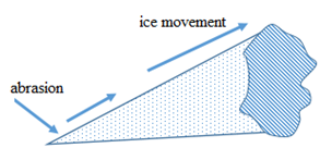
Abrasion: This is the wearing a way of rocks beneath a glacier by the scouring (scrapping) action of the rocks embedded in the glacier.
Feature produced by glacial erosion
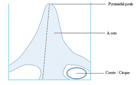
Cirque (corrie): A semi-circular, steep-sided basin cut into the side of a mountain, or at the head of a valley. It is formed by the process of plucking, which steepens the basin, and abrasion, which deepens the valley. Some corries contain glacier, but in others the glaciers have melted and they now contain lakes (sometimes called tarns). Examples of tarns are Lake Tana in Ethiopia and Teleki tarn on Mount Kenya.
Arete: A steep-sides, knife-edged separating two cirques. It is formed by the cutting back of the walls of cirques by plucking. Examples of found on Mount Kenya.
Pyramidal peak: A jugged peak with a steep sided, angular horn. It is formed by the steepening of the back walls several cirques which lie on the sides of a mountain. Examples of pyramidal peaks are found in Mountain Elgon.
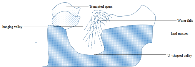
U-shaped valley: A steep-sided, flat- bottomed, wide valley contains features formed by both glacial erosion and deposition on the foot of the glaciated highland. It is formed by vertical and lateral erosion of moving ice. Most U-shaped valleys were originally river valleys.
Hanging valley: Are tributary valley of a U-shaped valley which ends abruptly, high above the floor of the U-shaped valley and separated from it by an almost vertical slope. It is formed due to unequal down cutting on the tributary valley.
Rock basin: An irregular depression in the floor of a U-shaped valley formed by unequal glacial erosion of the bedrock. It develops when the thickness and weight of a glacier increase, e.g. at the junction of two glaciers. Sometimes a rock basin becomes a lake when the glacier melts.
Ice-eroded plain: An extensive area once covered by an ice sheet which smoothed off the original landforms to give rounded topography, with large area of bare rock scratched boulders embedded in the base of the ice and rock basins in areas of weak rock, and the whole swept almost clean of the original weathered rock.
Roche Mountonnee: An outcrop of resistant rock smoothed by a glacier on the upstream side into a gentle slope. On the downstream side, the glacier eroded by plucking to give steep and jugged slope. It is formed where resistant rocks rise above the surrounding land surface. The upstream side of the rock is plucked to a steep slope.
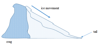
Crag and tail: A head of resistant rock which protected a weaker rock from ice erosion on the downstream side.
Truncated spurs: These are blunt-ended rock ridges which descend from the steep sides of a U-shaped valley or glacial through. They are often separated by hanging valley.
Before glaciations, relatively immature rivers display a pattern of interlocking spurs. A valley glacier cannot avoid the interlocking spurs as a river can. As the valley glacier moves, abrasion and plucking eroded the protruding tips of the spurs, leaving steep cliff-like truncated spurs.
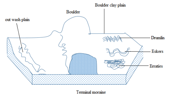
Depositional features of glaciations
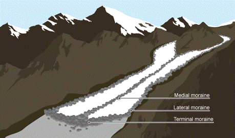
Moraine: These are unsorted rock fragment of all sizes, from sand to boulders, formed partly by frost action and partly by glacial abrasion, transported by a glacier and dumped in ridges or sheets.
Types of moraines
A moraine that forms along the sides of a glacier is called lateral moraine; that along the front of the glacier is called terminal moraine; and the at the bottom of the glacier is called ground moraine. When two glaciers join, their inner lateral moraines join together and give a medial moraine.
Boulder clay plain: A plain made of clay and boulders, deposited by ice sheets and glaciers over a surface.
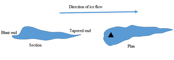
Drumlin: Elongated, oval-shaped hill made of boulder clay and about 1 km long and 25 to 100m wide.
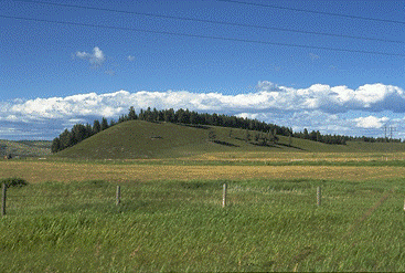
Each drumlin is a small hill, tending towards an egg shape, with its steepest slopes and summit at the up-ice end. Drumlins rarely occur singly, however, and are found in groups or swarms, with the tapered end of each hill pointing in the direction of glacier flow.
Eskers: An esker is a long, narrow, winding ridge of stratified sand gravel. The materials that form an esker are deposited by sub-glacier streams which retreat their way in the channel under the ice. Eskers reach up to 40 meters high. They are mostly found in Scandinavian countries.
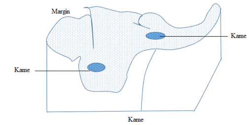
Kame: Is an irregular-shaped mass of stratified material formed as a delta on the surface of a stationary glacier or at its margin. It is a mound-like hill of poorly sorted material mostly sand and gravel, deposited at or near the terminus of a glacier. A kame may be produced either as a delta of a melt water stream or as an accumulation of debris let down onto the ground surface by the melting glacier.
Erratic: A glacial erratic is a piece of rock that differs from the size and type of rock native to the area in which it rests.
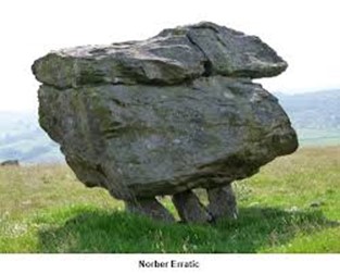
Most erratic can bound at Kimberlay (South Africa), North East USA and Wales in Britain