Weather: The conditions of the atmosphere which occur at a place at specific time period (from hour to hour or day to day) are known as weather.
Importance of weather:
- a) Good weather improves people‘s lives
edu.uptymez.com
b) Weather determines the kind of clothing to be worn by people in an area.
- c) Knowledge of the weather of a place enables people to carry out economic activities which can be sustained by the weather in that place. e.g. dairy cattle do well in a cool and wet place.
- d) By studying the weather of a place over a long time, we can establish its climate.
Weather and Human activities
Most human activities affected by weather that is experienced at a place.For example, When the rains are heavy, flooding occurs and causes damage to crops, animals and infrastructure like roads. This means that few economic activities can take place.
When there is no rain, plants and animals die, rivers and streams dry up, and irrigation and other economic activities like fishing cannot be carried out. Therefore weather affects the social economic activities of a place.Elements of Weather
Are the basic atmospheric condition of a place at a given time.
There are 7 element of weather
edu.uptymez.com
i) Sunshine
ii) Temperature
iii) Humidity
iv) Cloud cover
v) Precipitation
vi) Wind
vii) Atmospheric pressure
IMPORTANCE OF EACH ELEMENT OF WEATHER
i. Sunshine
Sunshine refers to the sun’s rays that reach the surface of the earth.
Importance of Sunshine:
- The sun’s energy enables plants to manufacture food through the process of photosysnthesis
- People need sunshine to dry their crops, food like cassava, millet, maize and fish
- They also use sunshine to warm themselves
edu.uptymez.com
Dries clothes after washing them
ii. Temperature
Refers to how hot or cold an object or place is.
The heat in the atmosphere is supplied by th sun
Importance of Temperature:
Warm is essential for plant and animal survival
Plants need warm in order to manufacture their fool
Facilitates formation of clouds
iii. Humidity
Is the amount of water vapor(moisture) in the atmosphere
There are two types of humidity:
a) Absolute humidity and
b) Relative humidity
a) Absolute humidity:
Is the actual amount of water vapor or moisture in a given volume of air at a particular temperature.
b) Relative humidity:
Is the ratio of the actual amount of water vapor or moisture in a given volume of air (i.e. absolute humidity) to the maximum amount of water vapor that the same volume of air can hold at the same temperature.
iv. Cloud cover
Clouds are masses of tiny droplets of water or ice particles or both which are suspended in the atmosphere.
They are formed when water vapor or moisture in the atmosphere cools and condenses.
Importance of cloud cover:
Are important because they condense to form rain and other forms of precipitation.
v. Precipitation
This refers as the fall or deposition of moisture water vapor or frozen water from the atmosphere onto the earths surface.
Importance of Precipitation:
- All life on the earth is purely dependent on moisture provided through precipitation
- The importance of rain is that, rain provides water for plants to grow (i.e. water for irrigation, growth of grass and pasture depend on rain)
- Also animals too need water to drink and human needs for domestic and industrial uses.
edu.uptymez.com
Note:
Excess rain and rainstorms result in disasters due to flooding
vi. Wind
Wind is air in motion. It is made up of variety of gases, such as oxygen and carbon dioxide. Wind move horizontally from areas of high pressure to areas of low pressure.
Importance of wind:
- They are important in many aspects of weather for instance they cause flow of heat and moisture and their transfer from one point to another and are also responsible for the movement of clouds.
- Wind direction and wind speed or velocity are two important aspects in geography. Wind direction is important because it help us to understand characteristics of the particular winds in terms of temperature and moisture content.
- Wind speed or velocity determines wind strength or force and therefore determines weather conditions of a place. Example, When strong winds blow over a place, little or no rainfall will be experienced.
edu.uptymez.com
vii. Atmospheric Pressure
This is the force at a point on the earth’s surface due to the weight of air above that point. The atmosphere is the air surrounding earth’s surface and it has weight, which is force with which it presses down on a unit area. The weight of atmosphere on the earth’s surface and at sea level at 1033.3g/cm2
-Areas of very low pressure cause feeling of weightlessness and that is the feeling one gets when he or she is on top of a very high mountain like Mt Kilimanjaro.
-Areas under very low pressure may experience very strong winds periodically as air flows into such areas from high pressure regions.
WEATHER STATION
Is a place where the elements of weather are measured and recorded. Examples of the elements are temperature, humidity, pressure, rainfall, wind direction and speed, cloud cover, and sunshine.

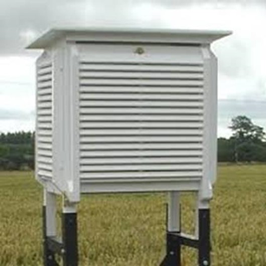
STEVENSON SCREEN
A Stevenson screen is made to allow air temperature to be measured. It consists of a wooden box with louver sides in order to allow free air to enter inside. In order to prevent sun’s heat to reach inside, the roof is double bodied. The screen is painted white to improve insulation. The screen is then placed on a stand which is about 121 centimeters above the ground. Other instruments include rain gauge, wind vane, anemometer, barometer, hygrometer, and the camp-bell stokes sunshine recorder. Weather and climate affect the physical environments as well as human activities.
1. Temperature:
Temperature is the degree of heat of a body, measured by a thermometer and expressed in degrees of a centigrade or Fahrenheit scales. There are several types of thermometer which shows the highest temperature reached during a day and the minimum thermometer which shows the lowest temperature reached.
Maximum thermometer
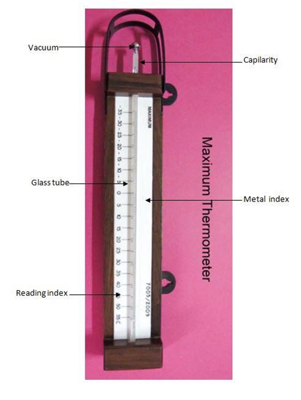
The figure above shows the maximum thermometer with a metal index. Thermometer is made of glass and it contains mercury in a bulb. A mercury column extends from a bulb at one end of the thermometer along a fine glass tube. The length of the mercury column shows changes in temperature when temperature rises, the mercury expands and the length of the column increases, pushing along the metal index.
The maximum temperature is read from the side of the metal index nearest to the mercury. When the temperature falls the mercury falls , leaving behind the metal index still indicating the maximum temperature reached. A magnet is used to bring back the metal index into contact with the mercury.
Minimum thermometer
The minimum thermometer contains alcohol instead of mercury. Alcohol is used because it has lower freezing point than mercury. Any fall in temperature will cause the alcohol column to contract and the meniscus (the curved upper surface of the alcohol column) will pull the index back along the tube whenever temperature rises, the alcohol will expand and flow freely past the metal index without pushing it up. Therefore the metal index is always left as a record of the lowest temperature reached between the readings. The part of the metal index away from the bulb will indicate the lowest temperature reached.
.
Six’s thermometer
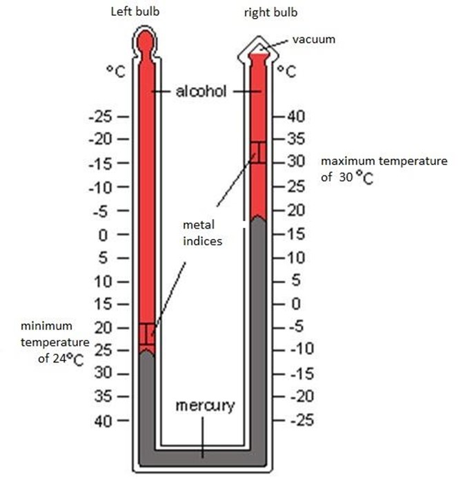
The six’s thermometer can also be used for measuring maximum and minimum temperature
The thermometer consists of a “U” shaped glass tube. The metal index nearest to the bulb indicates the minimum temperature and the other metal records the maximum temperature. When the mercury in the tube maximum temperature falls, the alcohol in the bulb contracts. This causes the mercury to push index B towards the bulb. The minimum temperature is read from the part of index B from the mercury.
Reading and Recording Temperature
Temperature reading is taken every day either at regular and fixed intervals (for example, after every four or six hours) or once in twenty four hours – In some meteorological stations temperature are recorded continuously by a self recording instrument called a thermograph. The maximum and minimum temperature which are recorded for a specific period of time are used to calculate;
Daily range of temperature, which is the different between the maximum and the minimum temperatures.
The mean daily temperature which is the average of the maximum and minimum temperature. The monthly range of temperature which is the difference between the highest mean daily temperature and the lowest mean daily temperature in a month. The annual range of temperature in a year which is the difference between the highest mean monthly temperature and the lowest mean monthly temperature.
To get a mean temperature daily for a month of a particular year add the mean daily temperature and divide the total by the number of days in that month. The average monthly temperature of a place such as Dar es Salaam for January is obtained by adding all the mean January temperature for thirty years or more and dividing the sum by the same number of years. This mean monthly temperature is used to show the temperature condition of the place for January.
When mean monthly temperature for a given month are obtained for many places, they can be shown on a map. Lines are drawn to connect places with the same mean monthly temperature. These lines are known as isotherms.
Mean January temperature in 0f.
The way of presenting temperature data for a town is by using a graph. Mean monthly temperature figures for a year are plotted on the graph and points are joined by a smooth line.
Factors affecting temperature
Factors that affect temperature include: altitude, ocean currents, distance from the sea, latitude and prevailing winds.
· Altitude
Temperature decreases with an increase in altitude at the rate of 0.60c for every 100 meters. That is why the summit of Mount Kilimanjaro with 5895 meters above sea level permanently covered with ice.
· Ocean currents
Ocean currents are either warm or cold. Warm currents raise the temperature of wind blowing across them while cold currents lower temperature of such winds. Some winds blowing on shore will influence the temperature of such winds in some of coastal areas with the temperature of the ocean currents.
· Distance from the sea
Distance from the sea affects temperature. This is because large areas of land masses lying at great distance from the sea do not get the moderating influence of the oceans. Lack of this moderating effects makes the land masses experience very low temperature in winter and very high temperature in summer. This extremely results in high annual range of temperature. The interior of the continent of Asia is a typical example.
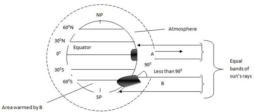
· Latitude
The amount of heat received at any place depends on the angle at which the sun’s rays strike the surface of the earth and the duration of sunshine. At the equator the sun’s rays reached the earth’s surface at almost right angles. Throughout the year but the angle decreases as one move towards the poles (fig 3.8) Therefore temperature decreases with increase in latitude because the sun rays spread over a larger area and its heating effect decreases.
EFFECTS OF LATITUDE ON TEMPERATURE
2. Humidity
The sun’s heat causes water to evaporate from the surface of the ocean and other water bodies. to form water vapor in the atmosphere.
Humidity is the amount of water vapor in air. Or
Humidity is the state of the atmosphere in relation to the amount of water vapour it contains. Humidity indicates the degree of dampness of the air and it is one of the main influences on weather. It is expressed in either absolute or relative terms.
Absolute humidity, expressed in grams per cubic meter, is the actual amount of water vapour present in a certain volume of air at a given temperature. Relative humidity is the amount of water vapour present in a mass of air expressed as a percentage of the total amount of water vapour that would be present when that air is saturated at the temperature. Air is saturated when the atmosphere cannot hold any more water vapour. This condition depends on the temperature and pressure of the air.
Humidity is measured by a hygrometer which consists of wet and dry bulb thermometers. The wet bulb thermometer is kept moist (wet) by wrapping it in a Muslin which is then dipped in a container of distilled water.
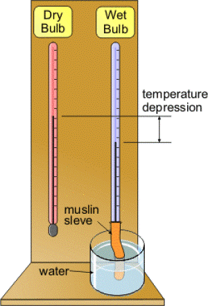
When the air is not saturated water evaporates from the muslin and cools the wet bulb. The cooling effect causes the mercury to contract. The dry bulb is not affected in the same way as wet bulb because it does have a Muslin wrapping. It is affected by the surrounding air. So when the air is not saturated the two thermometers show different readings, when the air is saturated the two thermometers show the same readings.
Therefore when there is a big difference in reading between the two thermometers humidity is low and when there is small difference humidity is high.
Exercise
1. Define the following terms:
a) Climate : Is the average weather condition of an area recorded over a long period of time ( over 30 year)
b) Weather station: Is an established area where daily records of weather are done accurately.
c) Temperature: Is the degree of heat of a body.
d) Maximum thermometer: Is used to show the highest temperature
e) Minimum thermometer: Used to show the lowest temperature
f) Humidity: Is the state of the atmosphere in relation to the amount of water vapour it contains.
(i) Absolute humidity: Is the actual amount of water vapour present in a certain volume of air at a given temperature
(ii) Relative humidity: Is the amount of water vapour present in a mass of air.
(iii) Weather: Is the condition of the atmosphere which occurs at place at a specific period of time (FROM HOUR TO HOUR OR DAY TO DAY).
2. Mention seven elements of weather and their instruments
i) Temperature-Thermometer
ii) Humidity-Hygrometer
iii) Precipitation- Rain gauge
iv) Clouds- Human eyes
v) Winds-Wind vane, anemometer
vi) Sunshine- Camp bel, Stokes sunshine recorder
vii) Pressure- Barometer
3. The records of maximum and minimum thermometers are used for;
i) Daily range temperature which is the difference of maximum and minimum thermometer.
ii) Daily temperature which is the average between maximum and minimum temperature.
4. How can you obtain the following;
a) Daily range temperature : Difference between maximum and minimum temperature.
b)Mean daily temperature : The average between maximum and minimum temperature.
5. Lines draws on a map to connect places with the same mean monthly temperature are known as Isotherms
6. Temperature data are presented by using Graph
7. List down five factors affecting temperature
i) Altitude
ii) Ocean currents
iii) Distance from the sea
iv) Latitude
v) Prevailing winds
3. Precipitation:
Precipitation refers to the deposition of moisture from the atmosphere on the earth’s surface. It includes dew, frost, snow, mist and hail, sleet and rain.
Dew:
Is the water vapor that condense on solid objects when the dew is reached.The droplets formed after condensation of water vapour which is then deposited on the cool surface such as building, leaves, grass and stones.
Frost:
Frost is a tiny ice crystals deposited on objects on the ground, frost is formed when temperature falls below freezing point.
Snow:
snow is the frozen droplets of water, snow formed when water vapour in the atmosphere turns into crystals of ice and reach the ground before melting.
Mist:
mist refers to tiny water droplets suspended immediately above the ground. Frost is similar to mist but it is denser with less visibility.
Hail:
Hail is the form of precipitation falling with small ice blocks, sleet is a mixture of snow and rain. It forms when the temperature of the ground is lower than the temperature above.
Rain:
Rain are the droplets of water falling from the atmosphere after condensation. When water vapour rises, It cools at high altitude until dew point is reached. Dew point is the temperature rate at which the atmosphere is saturated with water vapour. Condensation takes place after dew point has been reached to form water droplets. These droplets combine to form larger drops which fall as rain.
TYPES OF RAINFAL
a) Convectional rainfall
When rain is formed through vertical rising of moist air currents it is called convectional rain
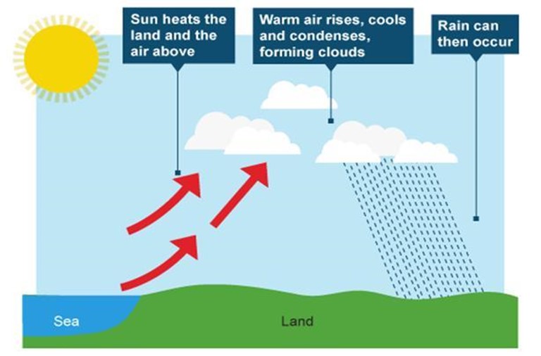
Convectional currents arise due to differential heating of the earth’s surface. Convectional rains are common in the tropical areas.
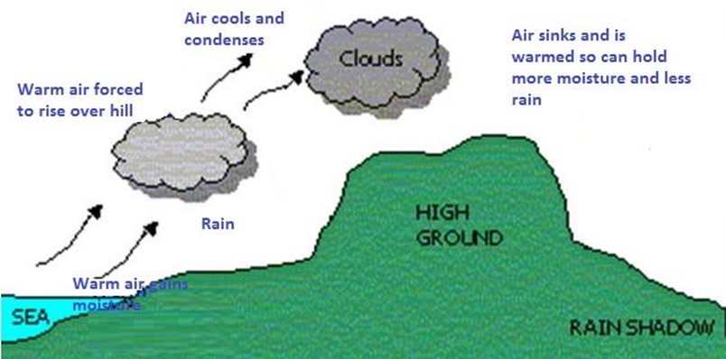
b) Relief rain
Sometimes moist winds are forced by a high mountain to rise and when they reach high altitude the moisture in them condenses to form droplets, which fall as rain.
Rain formed in this way is called relief or orthographical rain.
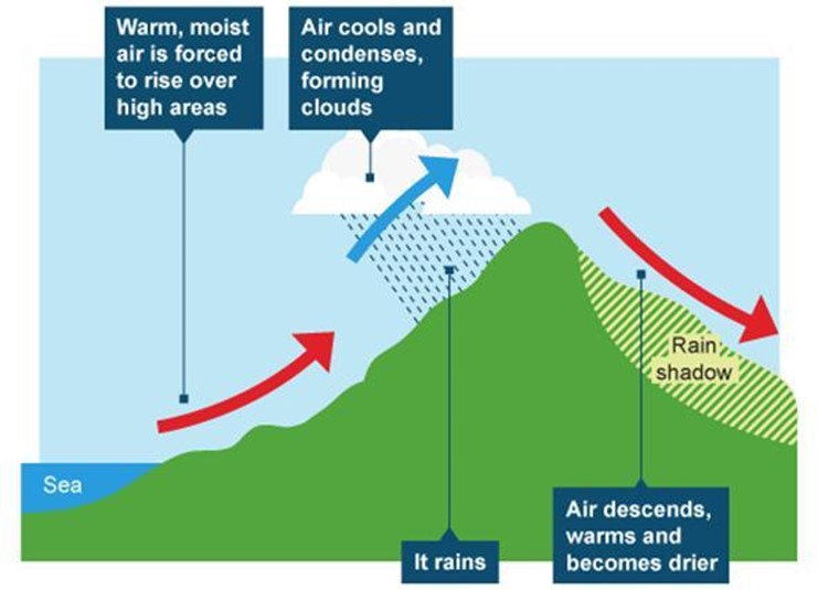
The sides of the mountain facing the direction of the winds is known as the wind ward side while that which faces away from the direction of the wind is known as the lee wards side or the rain shadow, the lee ward side gets very little rain . A typical example of rain shadow in Tanzania is found in the western side of mountain Kilimanjaro, winds blow from the Indian Ocean in the east and are forced by this mountain to rise and drop most of their moisture on the eastern and south eastern slopes. When these winds blow to the western side of the mountain they already relatively dry.
c) Cyclonic rain
When large masses of air with different characteristics of temperature and moisture, cyclonic rain may occur. As the warm and moist air is forced up over the cool and dry air, it expands. At higher altitude the warm air cools and water vapour condenses to form clouds and rain.
On the other hand tropical cyclones are formed over oceans is the tropical between latitude 80N and 80S. They usually bring very heavy rainfall and are associated with thunderstorms and very fast moving wind, which often causes destruction along coastal settlements . In the Caribbean and U.S.A tropical cyclones are called hurricanes in Africa they are known as cyclones and in China and Japan they are called typhoons.
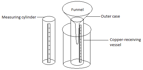
Rainfall is measured by using a rain gauge. The rain gauge consist of an outer case , a copper-receiving vessel, a funnel whose diameter is normally 13 centimeters, a clear glass jar or bottle and a graduated measuring cylinder.
Normally reading is done once every 24 hours. If necessary comments on the nature, time and duration of rainfall should be added to the record. Mean monthly rainfall for a station is usually obtained by adding up rainfall records of a particular month (say January) for a number of years (say 30 years) and dividing the total by the same number of years.

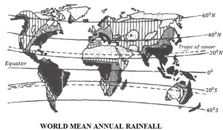
The figures so obtained can be presented in the form of graphs known as histogram. Figures for different places are plotted on a map and places with the same amount of rainfall are joined by smooth line. The line joined places with the same amount of rainfall are known as Isohyets
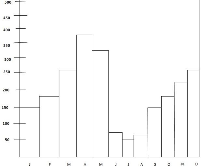
Mean Rainfall In Bukoba
Rainfall Variation.
Rainfall variation is a normal phenomenon on the earth which is caused by a number of factors. Some of them include Ocean currents, distance from the equator, prevailing winds, water bodies, nature and shape of the coast, distance from the sea, altitude and human activities.
Ocean Currents.
There are two types of Ocean Currents. The warms and the cold currents. The warm Ocean Currents yield rainfall over the adjustment land. This is because the winds cross over them do carry large amounts of moisture for example Mozambique current. Much rainfall is experienced along the East Coast of Africa.
Cold ocean currents are crossed by wind which have no moisture, hence brings very little or no rain in the adjacent land. For example banguera currents in south-west Africa coast and the canary current in the north-west coast of Africa.
Distance from the equator
Areas along the equator receive more rain than areas away from it. This is because of high amount of solar radiation, which result into evaporation and raising of air moisture hence condensation takes place resulting into convectional rainfall. Congo basin and Brazil are few examples which receive much rainfall due to their position.
Prevailing winds.
Winds blowing from the land towards the sea (off-shore) are carrying moist air from the land and yield no rainfall except in the sea. These winds usually lead to dryness of the land with very low rains in the coast. Effects of these winds are development of deserts. Eg, the Sahara Dessert in the North of Africa.
Lack of water bodies.
Areas with large water bodies such as areas around lake Victoria receive much rain than areas without water bodies like central Tanzania and North Eastern Kenya. Water bodies increase much rain to adjacent areas.
Nature and shape of the coast.
The coastal areas, which align parallel to the prevailing wind such as the N.E trade winds move parallel with the North Eastern Coast of Kenya, yield no rainfall. As result a dry climate is experienced along the coast.
Distance from the sea.
The areas near the sea or ocean experience high rainfall due to winds blowing moisture from the sea which would cause rainfall to the coastal areas. Areas that are very far from the sea receive very little or no rainfall for example, Dar es Salaam in Tanzania and Mombasa in Kenya receive heavier rains than Dodoma, Singida and Tabora, which have long distance from the Indian Ocean.
Altitude.
Altitude is also a factor for uneven nglish-swahili/distribution” target=”_blank”>distribution of rainfall, highlands force the warm air to rise over them. When they condense, they cause rain to fall on the wind ward side. The other side of the highland (leeward) may receive very little or no rainfall at all. People of such areas includes the eastern part of South Africa receives heavy rain (orographic) while the Western part experiences prolonged droughts due to effects of Drankensburg mountains. The eastern part of East Africa also receives heavier rainfall than the western side due to warm moist winds blowing from the Indian Ocean.
Human activity.
Besides other environmental benefit plants or trees intercept precipitation and return moisture to the air through transpiration and evaporation. This process becomes balanced when there is no destruction of the vegetation. Human activity such as settlement, animal rearing, farming and transportation however can cause rainfall variations on the earth’s surface through land degradation. When people cut trees or clear the bushes, land is naturally destroyed.
The destruction of vegetation disturbs evaporation, condensation and precipitation process, which are necessary elements of rainfall. In turn the amount of precipitation in the air is interrupted either by causing floods or droughts. The California desert in U.S.A and the Sahel in Africa are the results of droughts caused by human activities, which have led to the expansion of the deserts in the 1980s.
RAINFALL EFFECTS
Too much rainfall for example, the case of Elnino (1998) results into negative impacts on life and properties. Heavy rainfall may cause destruction of houses, roads and bridges, crop and loss of life for both human and animals. In addition to the loss of life and property, floods, which are the results of heavy rainfall results into eruption of diseases such as malaria, cholera, and dysentery.
On the other hand, too little rainfall leads to little yield of food and cash crops. Famine and hunger in the parts of the world is a result of lack of rainfall.
Prolonged dry seasons in some parts of the world have resulted into the loss of lives of both animals and the people. North Eastern Kenya, Somalia, Sudan, and Ethiopia are some of the areas where people and animals have lost their lives because of long droughts.
Rainfall reliability leads to continuous crops production and animal keeping hence improves standard of living and the industrial development of a nation may be realized. Sustainable agriculture is made possible and people are assured of enough food and cash crops.
Pressure.
The air surrounding the earth’s surface from the atmosphere. The atmosphere has weight. The force with which it presses down on a unit area is called atmospheric pressure. The pressure is exerted equally in all directions. To demonstrate that atmospheric pressure is exerted equally in all directions one can do the following experiment.
· Take a glass with full of water.
· Cover the top of the glass with a piece of thin paper
· Hold the glass upside down.
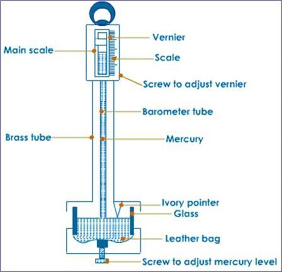
Atmospheric pressure is measured by an instrument called a barometer. There are two types of barometer, mercury barometer and aneroid barometer. A mercury barometer is a simple apparatus consisting of a glass of about 9.2 centimeters long and bowl filled with mercury.
The glass tube is filled with mercury and being put upside down in the bowl of mercury. At sea level the mercury will fall until the column is about 76 centimeters above the surface of the mercury in the bowl. A vacuum is left at the top of the tube. To read the pressure centimeter rule is placed besides the glass tube and the change in height of the mercury column gives the reading of the atmospheric pressure. Mercury barometers are not portable.
Barometer
Another instrument commonly used is the aneroid barometer. It consists of an air fight box of thin metal containing very little air. The top of this box moves inwards and outwards with changes in atmospheric pressure. This movement is transmitted by a system of levers to a circular seal with a pointer which shows the reading of atmospheric pressure.
Pressure is expressed in millimeters with reference to the height of mercury column or in millibars. A bar is the standard unit of pressure measurement. It is divided into one thousand units called millibars. At sea level pressure is one thousand millimeters of mercury or 1.5 kilograms of force per square centimeters. This is equivalent to 1013.2 millibars approximately one bar.
Lines joining places with the same pressure are called isobars and the pressure is greater at sea level where the whole thickness of the atmosphere exert its weight. Pressure decreases at the rate of 10 millibars for every 100 meters increase in height because the thickness of the atmosphere decreases.
Pressure
1. What is pressure?
Pressure is the air surrounding the earth’s surface forms the atmosphere.
2. Define atmospheric pressure – Is the force with which atmosphere presses down on a unit area
3. Atmospheric pressure is measured by a barometer
4. Two types of barometers are;
a) A mercury barometer.
b) Aneroid barometer.
5. Pressure is expressed in millimeter.
6. A bar is the standard unit of pressure measurement
7. It is divided into one thousand units called millibars.
8. Lines joining places with the same pressure is called isobars.
9. Mention three roles of pressure in human life.
a) Partial filling of tires hinders proper movement of the vehicle.
b) Pressure is also helpful to the patients whose parts of body fail and pump blood to other parts of the body.
c) Other pressured things include the decoration balloons and playing…
10.Pressure decreases at the rate of 10 millibars for every 100 meters
WINDS
Wind is air in motion from high pressure to low pressure area.
SEA BREEZE(DAY)
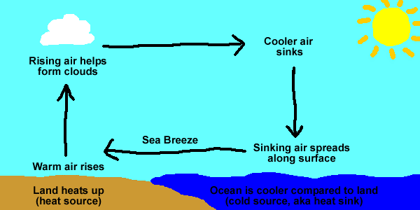
LAND BREEZE(NIGHT)
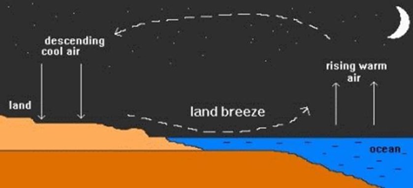
During the day the land is usually warmer than the sea, and the air pressure on the land is lower than that over the sea. Therefore winds blow from sea to land. These winds are known as sea breezes. During the night the land is cooler than the sea and there is low pressure on the sea. Therefore winds blow from land to sea, these are called land breezes.
There are great variations in the general patterns of wind systems in areas of the earth’s surface where there are large land masses adjacent to large water bodies. During summer, intense low pressure develops in central Asia in the Northern hemisphere and winds blow inform of high pressure over the Indian and pacific oceans.
July wind pattern
During winter, intense high pressure develops in central Asia while intense low pressure develops over the Indian Ocean causing winds to blow from the land to the ocean. Such winds that reverse their direction with changes in seasons are called monsoon winds. The word monsoon is derived from an Arabic word “mausin” which means season.
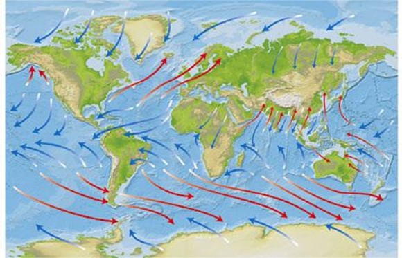
January breeze
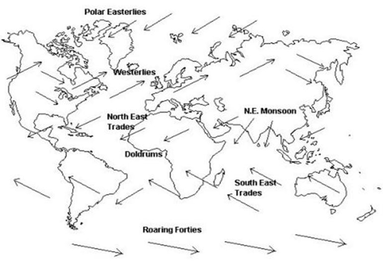
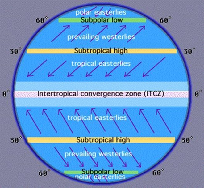
In the equatorial belt of low pressure between 5oN and 50S, intense solar heating causes the moist air to rise in great convention currents. This belt is called the doldrums or low pressure belt. The rising air spreads out and moves towards the poles. In so doing it cools and sinks from a high pressure belt. This take place around latitude 300N and, these latitudes are called horse latitudes or subtropical high pressure belts.
In latitudes 300N and 300S some of the high pressure air moves the surface towards the equator as the north- east and south-east trade winds, and some of it moves over the surface towards the poles as the western. Cold air blowing from the poles southwards and northwards expand and its pressure falls. These low pressure belts become noticeable around latitude 600N and 600S. As air moves away from the poles most of it moves in from higher levels to take its place. Thus in each hemisphere there are three winds systems; One operates between north poles and latitude 600N and between the south poles and latitude 600S (polar winds) and a second one operates between latitude 300N and 600N and between latitude 300S and 600S (the westerly winds).
Wind belts of the world
Occasionally in the westerly wind system depressions and anticyclones develop. A depression is an area of low pressure in which winds blow a circular motion. This motion is anti-clockwise in the Northern hemisphere but clockwise in the southern hemisphere. A depression develops when cold heavy air comes into contact with warm moisture. A depression is usually associated with cyclonic rains. Anticyclones are areas of high pressure in which winds blow in a clockwise circular motion in the Northern hemisphere. They normally follow a depression and are associated with cool fine weather with no rain.
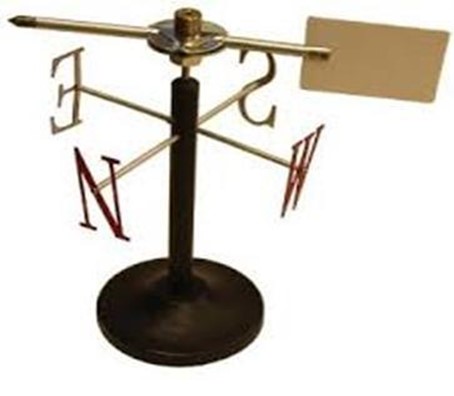
Wind direction is measured by a wind-vane. A wind-vane consists of a freely rotating arrow fitted to a central rod. The arrow of the wind-vane always points to the direction from which winds blows, and the wind is named after this direction. Four arms marking the directions of the cardinal points are fixed to the stationary central rod.
Wind- vane

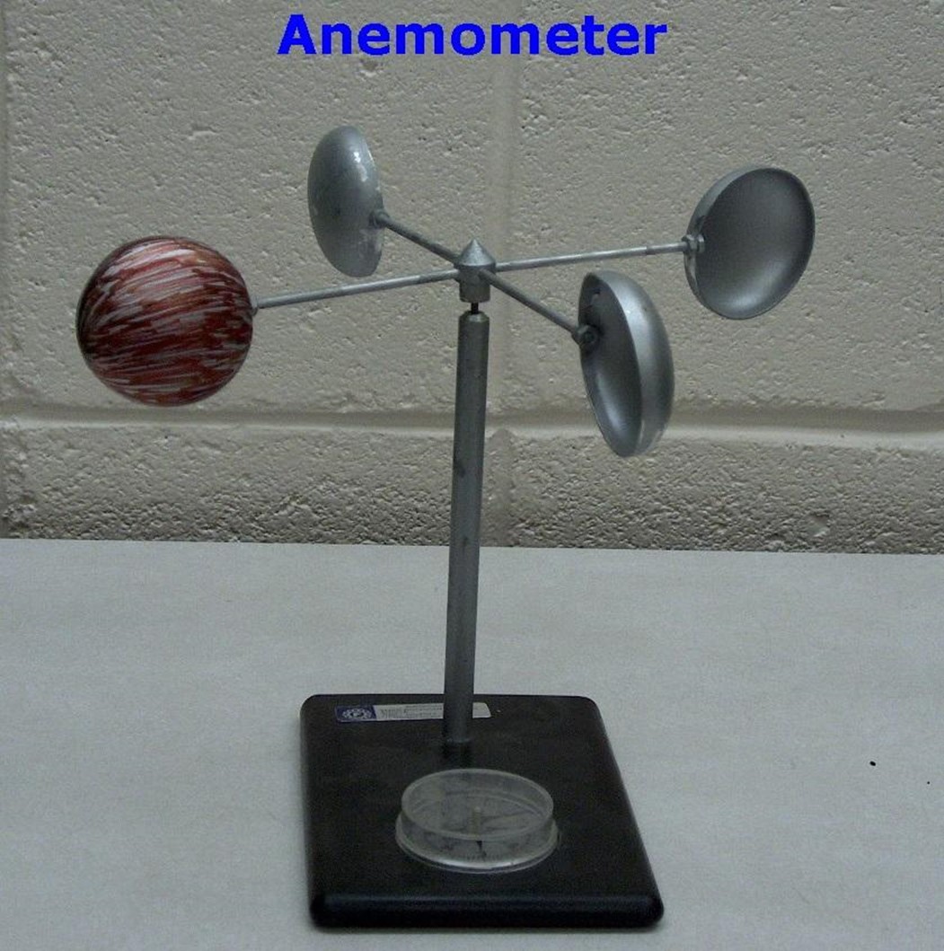
Wind speed is measured by an instrument called an anemometer. This instrument consists of three or four horizontal arms that when there is wind the arms rotate. This movement operates a meter which records the speed of the wind in kilometers per hour.
Anemometer
Weather forecasting
Weather forecasting is defined as a prediction of weather condition of a place at a given time approximately 24 + 48hrs. Weather forecasting is obtained through two methods namely, traditional and modern methods.
The traditional method predicts weather through observation of types of birds voices, crocking of frogs, rainbow, migration of birds, changes of wind direction, position of the moon and general body feeling. The method is still widely used in predicting weather by the indigenous communities.
Modern method involves the use of modern equipment such as satellites, electronic computers, radar, and aircraft, balloons, ships, submarines, rockets and daily records from weather stations. This method of predicting weather is more reliable and accurate.
METHODS AND INSTRUMENTS USED FOR WEATHER FORECASTING (MODERN METHODS)
1. Radiosonde
This is an instrument used to register pressure and temperature from the ground to roughly 12km above the ground. The instruments are fixed to balloons filled with helium gas and are released into the atmosphere every day at a particular time from different weather stations. The radiosonde transmits radio signals to computers on the ground station where they are analyzed. The signal transmitted give pressure, temperature and humidity readings at different altitude. These balloons are made in such a way that they burst when they reach a certain altitude.
2. Satellite
The satellite used for predicting weather are human made space. They move around the earth so that they can provide various types of information. They are also used in radio, television and telephone communication. Satellite transmits photographs on weather conditions on a daily basis. The movement of clouds can be predicted from an analysis of the movement of winds force period of 24hours.
3. Persistence method
This is simpler way of making a weather forecast. It assumes that the atmosphere conditions of a place at the time of forecast will not change. For example, if it is 28°C in Dodoma today the persistence method predicts that it will still be 28°C in Dodoma tomorrow. If two inches of rain fell in Arusha yesterday, this method predicts that two inches of rain will fall in Arusha today.
4. Statistical forecasting
In this method, meteorologists ask themselves how is the weather usually like at this time of the year?. They then collect records of average temperatures and rainfall over the last five years. This give forecasters an idea of what the weather is “supposed to be like” at the certain time of year.
Weather forecasting is useful to people in the following ways;
a) Farmers planning their work for a year. This is because weather broad casting helps farmers to adjust their farming activities to suit the expected weather conditions.
b) Weather broadcasting greatly influence transport since it helps sailors and air travelers to know condition of the winds.
c) Helps in planning sport activities.
d) Helps in selecting suitable clothes.
e) Helps fishermen to plan their fishing activities.
f) Helps contractors to plan for a suitable houses.
g) Helps in geographical expeditions like tours and military.
h)Military personnel benefit from weather broadcasting as they can plan their military activities depending on weather conditions
Exercise
1. If the temperature at Dar- es-salaam, which is at sea level, is 32oc, the temperature at a place where altitude is 1,500 meters will be
a) 0.60c
b) 230c (C)
c) 80c
d) 170c
2. Circle the letter of the correct response for the following statements.
To obtain the mean monthly temperature of a place for a month in a particular year, take
a) The sum of mean daily temperature for the month.
Number of days in the month.
b) The sum of the monthly temperature x12
Numbers of days in the month.
c) The sum of the monthly temperature for the year
12 months
d) The daily maximum + the daily minimum
2.
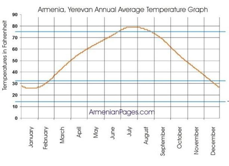
3) Study the Temperature graph for Delhi below and answer the following;
a) Which is the coldest month?
b) Which is the hottest month?
c) Calculate the annual range of Temperature.